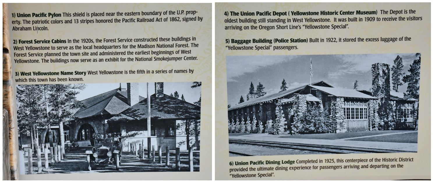
Founded in June 1908 when the Oregon Short Line Railroad was completed, the town’s name changed several times until West Yellowstone was settled upon in 1920. Train service to West Yellowstone ended in 1960. The town was incorporated in 1966.
x
x
We had been told that West Yellowstone served the best bison meat in the world, so we headed to the restaurant we found on Google with the best reviews. We are not wrong. Actually, one could not differentiate beef from bison meat… but we could say now that we had eaten bison.
x
Bison are so important in West Yellowstone, Montana, that they even have a monument at the entrance to the town.Bison are large bovines in the genus Bison within the tribe Bovini. Two extant species and numerous extinct species are recognized. Of the two surviving species, the American bison, B. bison, found only in North America, is the more numerous. Although colloquially referred to as a buffalo in the United States and Canada, it is only distantly related to the true buffalo. The North American species is composed of two subspecies, the Plains bison, B. b. bison, and the wood bison, B. b. athabascae, which is the namesake of Wood Buffalo National Park in Canada. A third subspecies, the eastern bison (B. b. pennsylvanicus) is no longer considered a valid taxon, being a junior synonym of B. b. bison. References to “woods bison” or “wood bison” from the eastern United States refer to this subspecies, not B. b. athabascae, which was not found in the region. The European bison, B. bonasus, or wisent, or zubr, or colloquially European buffalo, is found in Europe and the Caucasus, reintroduced after being extinct in the wild.
While bison species have been traditionally classified in their own genus, modern genetics indicates that they are nested within the genus Bos, which includes, among others, cattle, yaks and gaur, being most closely related to yaks. Bison are sometimes bred with domestic cattle and produce offspring called beefalo or zubron.
x
Of course, you could not miss knowing the beginnings of the famous Yogi bear. Yogi Bear is a anthropomorphic animal character who has appeared in numerous comic books, animated television shows and films. He made his debut in 1958 as a supporting character in The Huckleberry Hound Show.Yogi Bear was the first breakout character in animated television; he was created by Hanna-Barbera and was eventually more popular than ostensible star Huckleberry Hound. In January 1961, he was given his own show, The Yogi Bear Show, sponsored by Kellogg’s, which included the segments Snagglepuss and Yakky Doodle. Hokey Wolf replaced his segment on The Huckleberry Hound Show. A musical animated feature film, Hey There, It’s Yogi Bear!, was released in 1964.
Yogi was one of several Hanna-Barbera characters to have a collar. This allowed animators to keep his body relatively static, redrawing only his head in each frame when he spoke – one of the ways Hanna-Barbera cut costs, reducing the number of drawings needed for a seven-minute cartoon from around 14,000 to around 2,000.
x
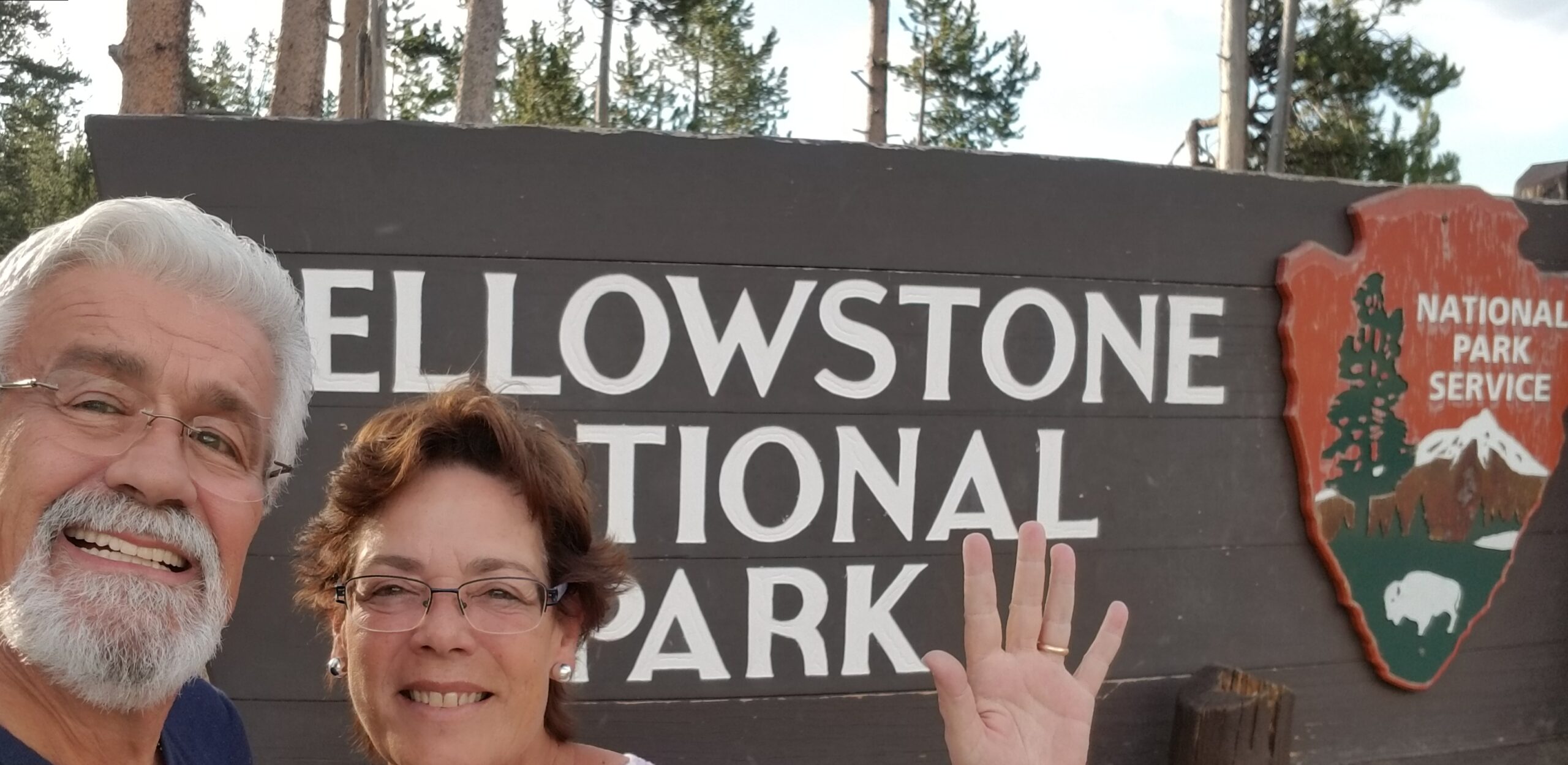
After touring West Yellowstone, taking all the videos and photos and even doing a few shopping, we headed to the famous Yellowstone National Park. Yellowstone National Park is an American national park located in the western United States, largely in the northwest corner of Wyoming and extending into Montana and Idaho. It was established by the U.S. Congress and signed into law by President Ulysses S. Grant on March 1, 1872. Yellowstone was the first national park in the U.S. and is also widely held to be the first national park in the world. The park is known for its wildlife and its many geothermal features, especially the Old Faithful geyser, one of its most popular. While it represents many types of biomes, the subalpine forest is the most abundant. It is part of the South Central Rockies forests ecoregion.While Native Americans have lived in the Yellowstone region for at least 11,000 years, aside from visits by mountain men during the early-to-mid-19th century, organized exploration did not begin until the late 1860s. Management and control of the park originally fell under the jurisdiction of the United States Department of the Interior, the first Secretary of the Interior to supervise the park being Columbus Delano. However, the U.S. Army was eventually commissioned to oversee management of Yellowstone for a 30-year period between 1886 and 1916. In 1917, administration of the park was transferred to the National Park Service, which had been created the previous year. Hundreds of structures have been built and are protected for their architectural and historical significance, and researchers have examined more than a thousand archaeological sites.
x
x
x
x
x
Yellowstone National Park spans an area of 3,468.4 sq mi (8,983 km2), comprising lakes, canyons, rivers, and mountain ranges. Yellowstone Lake is one of the largest high-elevation lakes in North America and is centered over the Yellowstone Caldera, the largest super volcano on the continent. The caldera is considered a dormant volcano. It has erupted with tremendous force several times in the last two million years. Well over half of the world’s geysers and hydrothermal features are in Yellowstone, fueled by this ongoing volcanism. Lava flows and rocks from volcanic eruptions cover most of the land area of Yellowstone. The park is the centerpiece of the Greater Yellowstone Ecosystem, the largest remaining nearly intact ecosystem in the Earth’s northern temperate zone. In 1978, Yellowstone was named a UNESCO World Heritage Site.
Hundreds of species of mammals, birds, fish, reptiles, and amphibians have been documented, including several that are either endangered or threatened. The vast forests and grasslands also include unique species of plants. Yellowstone Park is the largest and most famous megafauna location in the contiguous United States. Grizzly bears, wolves, and free-ranging herds of bison and elk live in this park. The Yellowstone Park bison herd is the oldest and largest public bison herd in the United States. Forest fires occur in the park each year; in the large forest fires of 1988, nearly one third of the park was burnt. Yellowstone has numerous recreational opportunities, including hiking, camping, boating, fishing, and sightseeing. Paved roads provide close access to the major geothermal areas as well as some of the lakes and waterfalls. During the winter, visitors often access the park by way of guided tours that use either snow coaches or snowmobiles.
x
The park contains the headwaters of the Yellowstone River, from which it takes its historical name. Near the end of the 18th century, French trappers named the river Roche Jaune, which is probably a translation of the Hidatsa name Mi tsi a-da-zi (“Yellow Rock River”).[19] Later, American trappers rendered the French name in English as “Yellow Stone”. Although it is commonly believed that the river was named for the yellow rocks seen in the Grand Canyon of the Yellowstone, the Native American name source is unclear.[20]
x

Detailed pictorial map from 1904
The human history of the park began at least 11,000 years ago when Native Americans began to hunt and fish in the region. During the construction of the post office in Gardiner, Montana, in the 1950s, an obsidian point of Clovis origin was found that dated from approximately 11,000 years ago. These Paleo-Indians, of the Clovis culture, used the significant amounts of obsidian found in the park to make cutting tools and weapons. Arrowheads made of Yellowstone obsidian have been found as far away as the Mississippi Valley, indicating that a regular obsidian trade existed between local tribes and tribes farther east.[22] By the time white explorers first entered the region during the Lewis and Clark Expedition in 1805, they encountered the Nez Perce, Crow, and Shoshone tribes. While passing through present-day Montana, the expedition members heard of the Yellowstone region to the south, but they did not investigate it.
x
x
In 1806, John Colter, a member of the Lewis and Clark Expedition, left to join a group of fur trappers. After splitting up with the other trappers in 1807, Colter passed through a portion of what later became the park, during the winter of 1807–1808. He observed at least one geothermal area in the northeastern section of the park, near Tower Fall. After surviving wounds he suffered in a battle with members of the Crow and Blackfoot tribes in 1809, Colter described a place of “fire and brimstone” that most people dismissed as delirium; the supposedly mystical place was nicknamed “Colter’s Hell“. Over the next 40 years, numerous reports from mountain men and trappers told of boiling mud, steaming rivers, and petrified trees, yet most of these reports were believed at the time to be myth.
x
x
After an 1856 exploration, mountain man Jim Bridger (also believed to be the first or second European American to have seen the Great Salt Lake) reported observing boiling springs, spouting water, and a mountain of glass and yellow rock. These reports were largely ignored because Bridger was a known “spinner of yarns”. In 1859, a U.S. Army Surveyor named Captain William F. Raynolds embarked on a two-year survey of the northern Rockies. After wintering in Wyoming, in May 1860, Raynolds and his party—which included naturalist Ferdinand Vandeveer Hayden and guide Jim Bridger—attempted to cross the Continental Divide over Two Ocean Plateau from the Wind River drainage in northwest Wyoming. Heavy spring snows prevented their passage, but had they been able to traverse the divide, the party would have been the first organized survey to enter the Yellowstone region.[25] The American Civil War hampered further organized explorations until the late 1860s.
Ferdinand V. Hayden (1829–1887), American geologist who convinced Congress to make Yellowstone a national park in 1872
The first detailed expedition to the Yellowstone area was the Cook–Folsom–Peterson Expedition of 1869, which consisted of three privately funded explorers. The Folsom party followed the Yellowstone River to Yellowstone Lake. The members of the Folsom party kept a journal- based on the information it reported, a party of Montana residents organized the Washburn–Langford–Doane Expedition in 1870. It was headed by the surveyor-general of Montana Henry Washburn, and included Nathaniel P. Langford (who later became known as “National Park” Langford) and a U.S. Army detachment commanded by Lt. Gustavus Doane. The expedition spent about a month exploring the region, collecting specimens and naming sites of interest.
x
x
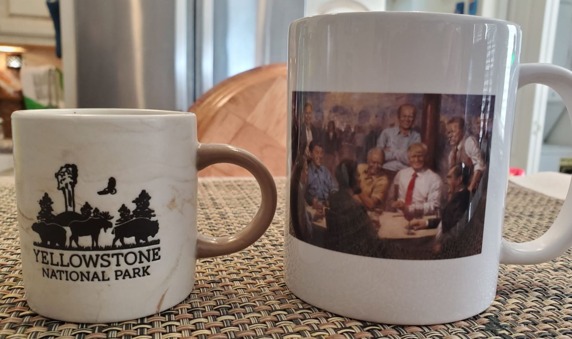
Expresso coffee cup bought by Siomi for our late friend Carla Rivas
x
A Montana writer and lawyer named Cornelius Hedges, who had been a member of the Washburn expedition, proposed that the region should be set aside and protected as a national park; he wrote detailed articles about his observations for the Helena Herald newspaper between 1870 and 1871. Hedges essentially restated comments made in October 1865 by acting Montana Territorial Governor Thomas Francis Meagher, who had previously commented that the region should be protected. Others made similar suggestions. In an 1871 letter from Jay Cooke to Ferdinand V.Hayden, Cooke wrote that his friend, Congressman William D. Kelley had also suggested “Congress pass a bill reserving the Great Geyser Basin as a public park forever”
One of the great attractions of Yellowstone is the famous “Old Faithful”.
x
In the afternoon of September 18, 1870, the members of the Washburn-Langford-Doane Expedition traveled down the Firehole River from the Kepler Cascades and entered the Upper Geyser Basin. The first geyser that they saw was Old Faithful. Nathaniel P. Langford wrote in his 1871 Scribner’s account of the expedition:
It spouted at regular intervals nine times during our stay, the columns of boiling water being thrown from ninety to one hundred and twenty-five feet at each discharge, which lasted from fifteen to twenty minutes. We gave it the name of “Old Faithful.”
— Nathaniel P. Langford, 1871
In the early days of the park, Old Faithful was often used as a laundry. Old Faithful is sometimes degraded by being made a laundry. Garments placed in the crater during quiescence are ejected thoroughly washed when the eruption takes place. Gen. Sheridan‘s men, in 1882, found that linen and cotton fabrics were uninjured by the action of the water, but woolen clothes were torn to shreds.
More than 1,000,000 eruptions have been recorded. Harry Woodward first described a mathematical relationship between the duration and intervals of the eruptions in 1938. Old Faithful is not the tallest or largest geyser in the park; those titles belong to the less predictable Steamboat Geyser. The reliability of Old Faithful can be attributed to the fact that it is not connected to any other thermal features of the Upper Geyser Basin.
Eruptions can shoot 3,700 to 8,400 US gallons (14,000 to 32,000 L) of boiling water to a height of 106 to 185 feet (32 to 56 m) lasting from 1+1⁄2 to 5 minutes. The average height of an eruption is 145 feet (44 m). Intervals between eruptions can range from 60 to 110 minutes, averaging 66.5 minutes in 1939, slowly increasing to an average of 90 minutes apart today, which may be the result of earthquakes affecting subterranean water levels. The disruptions have made earlier mathematical relationships inaccurate but have actually made Old Faithful more predictable in terms of its next eruption. After the Borah Peak earthquake in central Idaho in October 1983, the eruption intervals of Old Faithful were noticeably lengthened.
We passed by the “Snake River”.The Snake River is a major river of the greater Pacific Northwest region in the United States. At 1,078 miles (1,735 km) long, it is the largest tributary of the Columbia River, in turn the largest North American river that empties into the Pacific Ocean. The Snake River rises in western Wyoming, then flows through the Snake River Plain of southern Idaho, the rugged Hells Canyon on the Oregon–Idaho border and the rolling Palouse Hills of Washington, emptying into the Columbia River at the Tri-Cities in the Columbia Basin of Eastern Washington.
The Snake River drainage basin encompasses parts of six U.S. states (Idaho, Washington, Oregon, Utah, Nevada, and Wyoming) and is known for its varied geologic history. The Snake River Plain was created by a volcanic hotspot which now lies underneath the Snake River headwaters in Yellowstone National Park. Gigantic glacial-retreat flooding episodes that occurred during the previous Ice Age carved out canyons, cliffs and waterfalls along the middle and lower Snake River. Two of these catastrophic flooding events, the Missoula Floods and Bonneville Flood, significantly affected the river and its surroundings.
Native Americans have lived along the Snake for more than 11,000 years. Salmon from the Pacific Ocean spawned by the millions in the river, and were a vital resource for people living on the Snake downstream of Shoshone Falls. By the time Lewis and Clark explored the area, the Nez Perce and Shoshone were the dominant Native American groups in the region. Later explorers and fur trappers further changed and used the resources of the Snake River basin. At one point, sign language used by the Shoshones representing weaving baskets was misinterpreted to represent a snake, giving the Snake River its name.
By the middle 19th century, the Oregon Trail had become well established, bringing numerous settlers to the Snake River region. Steamboats and railroads moved agricultural products and minerals along the river throughout the 19th and early 20th centuries. Starting in the 1890s, fifteen major dams have been built on the Snake River to generate hydroelectricity, enhance navigation, and provide irrigation water. However, these dams blocked salmon migration above Hells Canyon and have led to water quality and environmental issues in certain parts of the river. The removal of several dams on the lower Snake River has been proposed, in order to restore some of the river’s once-tremendous salmon runs.
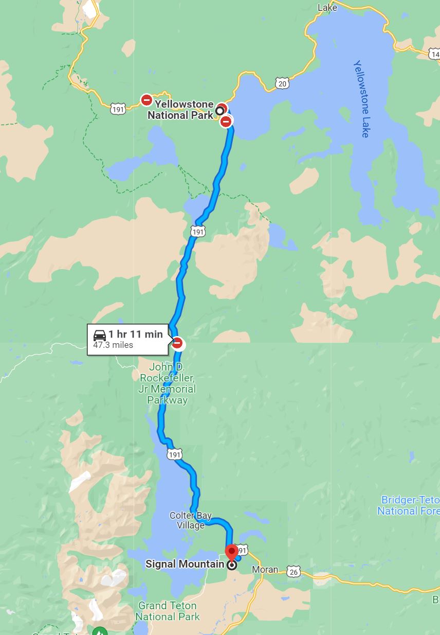
Then we stopped Lewis Lake. Lewis Lake is located in the U. S. state of Wyoming in the southern part of Yellowstone National Park, about 4 miles (6.4 km) southeast of Shoshone Lake, and approximately 10 miles (16 km) southwest of Yellowstone Lake. Lewis Lake and Shoshone Lake are both located a few miles northeast of the Pitchstone Plateau.
The Lewis River is the lake’s primary inflow, draining south from Shoshone Lake. The primary outflow of Lewis Lake is also the Lewis River, continuing south to join the Snake River near the southern boundary of Yellowstone National Park. A few small creeks also feed Lewis Lake. There are several hot springs emptying into the lake on its northwestern shore and two more hot springs at the lake’s southern end where it empties into the Lewis River. A campground is located on the lake’s southeast shore. Yellowstone National Park’s South Entrance Road (which is also numbered as U.S. Route 287, U.S. Route 89, and U.S. Route 191), run along the east side of Lewis Lake. Like the river, Lewis Lake is named for Meriweather Lewis, commander of the Lewis and Clark Expedition.
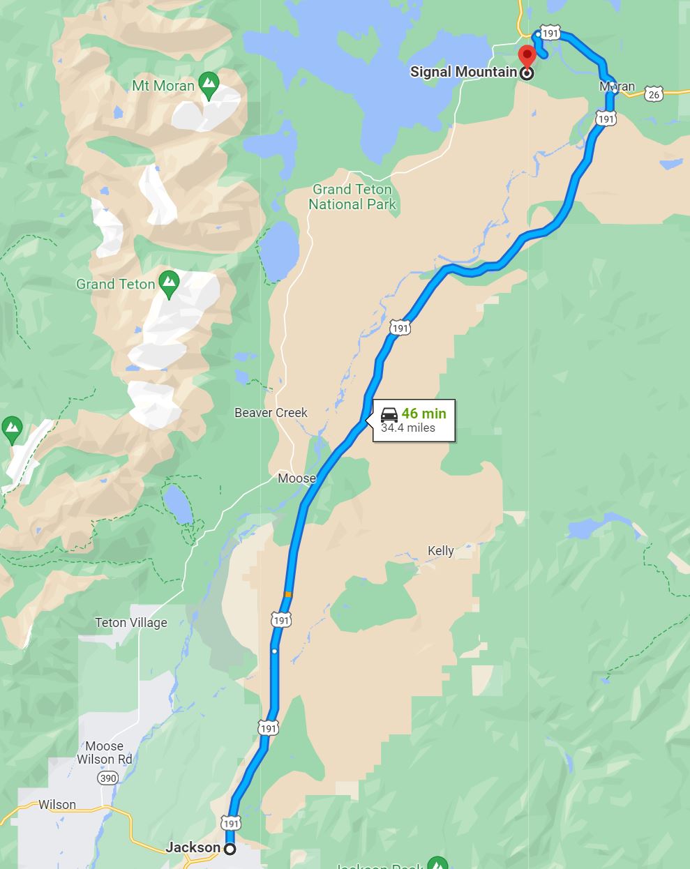
Lewis’s lake holds brown, brook and lake trout and falls within the non-native trout tolerance area of the park. Anglers may keep up to five non-native trout per day but only one brown trout. And we stopped at Signal Mountain, where bears are problematic. We thought about spending the night there, but we decided to continue on our way: we are very-much afraid of bears.
Signal Mountain is an isolated summit standing 7,720 feet (2,350 m) above sea level. The mountain is located in Grand Teton National Park in the U.S. state of Wyoming. The next closest higher summit is more than 10 miles (16 km) distant, and this isolation provides sweeping views of the Teton Range, much of the northern Jackson Hole area as well as the Snake River. Though located adjacent to the Tetons, Signal Mountain was not formed in the same manner or period. The mountain originally was formed by volcanic ashfall from one of the eruptions of the Yellowstone hotspot. The peak is also partially a glacial moraine formed by a receding glacier that came south out of the Yellowstone icecap.[4] This same glacier also created neighboring Jackson Lake.
x
x
Jackson was originally populated by Native American tribes including the Shoshoni, Crow, Blackfeet, Bannock, and Gros Ventre. In the early 1800s, the locality became a prime area for trappers and mountain men to travel through, one example being John Colter. After being discharged from the Corps of Discovery of the Lewis and Clark Expedition in 1806 at Fort Mandan, in present-day North Dakota, Colter visited Jackson Hole during the winter of 1807/1808. Among other mountain men who visited the valley include Jim Bridger, Jedediah Smith, and William Sublette, who are responsible for many of the names in the area. David Edward Jackson gave his name to the valley after a winter spent on the shores of Jackson Lake.
As part of the Hayden Expedition of 1871 and 1872, William Henry Jackson took the first photographs of the Teton Mountains and Yellowstone. His photographs, along with the sketches by Tom Moran, were important evidence to convince Congress to protect Yellowstone National Park. Yellowstone National Park became the first National Park in 1872. Grand Teton National Park was created in 1929 and greatly expanded in 1950 through the generous efforts of John D. Rockefeller, Jr., who purchased and then donated over 30,000 acres.
The Town of Jackson was named in 1894 and incorporated in 1914. Some of the early buildings remain and can be found throughout the area of the Town Square. The Town of Jackson elected the first all-woman city government (including town council and mayor, who in turn appointed women to town marshal, town clerk and treasurer) in 1920.
The first ski rope tow was built at Teton Pass in 1937 and Snow King Resort was established in 1930. Teton County now has three excellent ski areas including Jackson Hole Mountain Resort in Teton Village, Grand Targhee Ski and Summer Resort located on the West slope of the Tetons, and Snow King Resort.
The Town of Jackson is the county seat of Teton County and the only incorporated municipality in the region. Less than 3% of land in Teton County is privately owned. 97% of the 2,697,000 acres in Teton County are federally or state owned/managed.
In 2009, the Town of Jackson was designated as a Preserve America Community. This designation recognizes that, as a community, the town protects and celebrates its heritage, uses historic assets for economic development and encourages people to experience and appreciate local historic resources.
In September 2016, the town went viral from an ongoing live stream on YouTube consisting of various views of the town, especially a webcam angled on the town square. Notable interests were the abundance of red trucks in the streets and a sheriff performing the dab in front of the live webcam. To date, the webcam is still operational
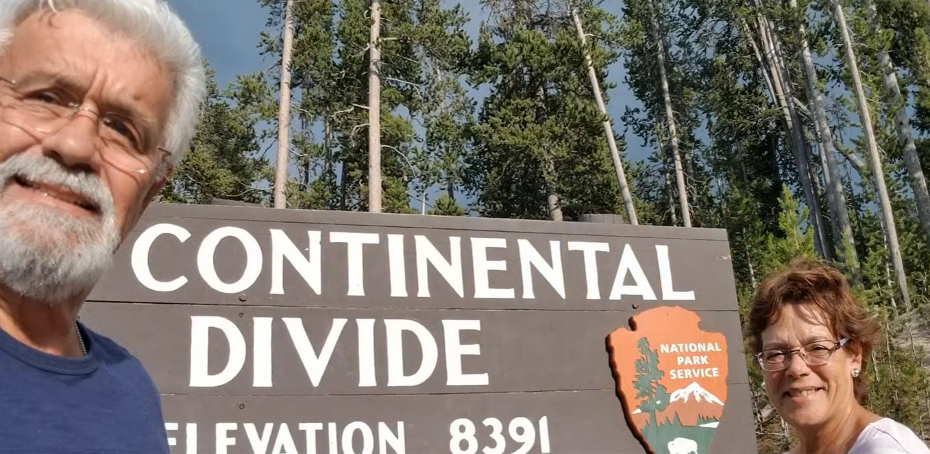
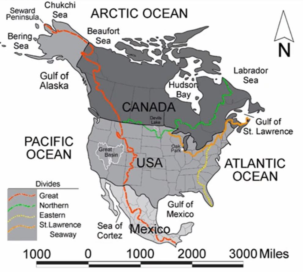
Continental Divide
x
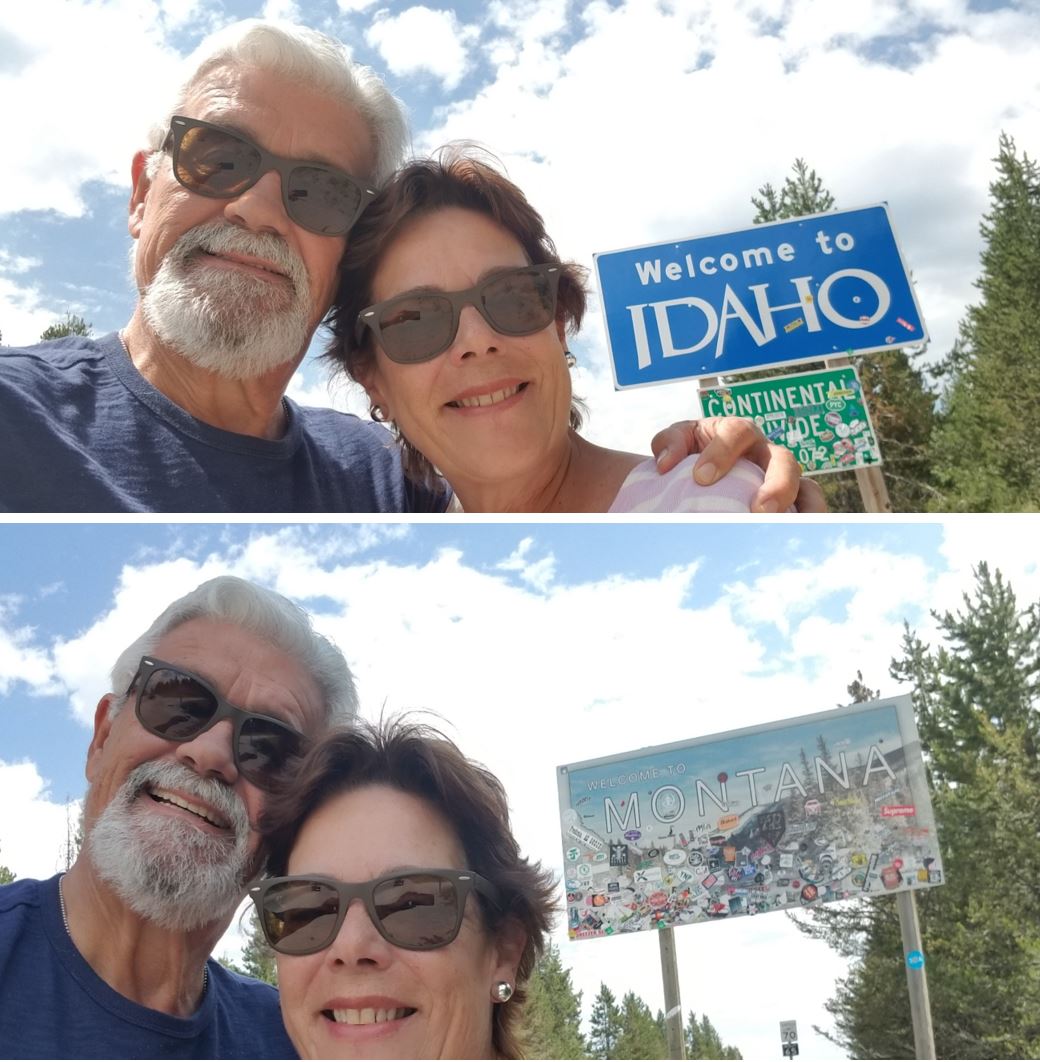
We cross the “Continental Divide”. The Continental Divide of the Americas (also known as the Great Divide, the Western Divide or simply the Continental Divide; Spanish: Divisoria continental de América, Gran Divisoria) is the principal, and largely mountainous, hydrological divide of the Americas. The Continental Divide extends from the Bering Strait to the Strait of Magellan, and separates the watersheds that drain into the Pacific Ocean from those river systems that drain into the Atlantic and (in northern North America) Arctic oceans (including those that drain into the Gulf of Mexico, the Caribbean Sea and Hudson Bay).
x
x
Although there are many other hydrological divides in the Americas, the Continental Divide is by far the most prominent of these because it tends to follow a line of high peaks along the main ranges of the Rocky Mountains and Andes, at a generally much higher elevation than the other hydrological divisions.
From there we flew to Salt Lake City, on our way to Spokane, Washington State.
Index
Yellowstone (Montana – Wyoming)
x