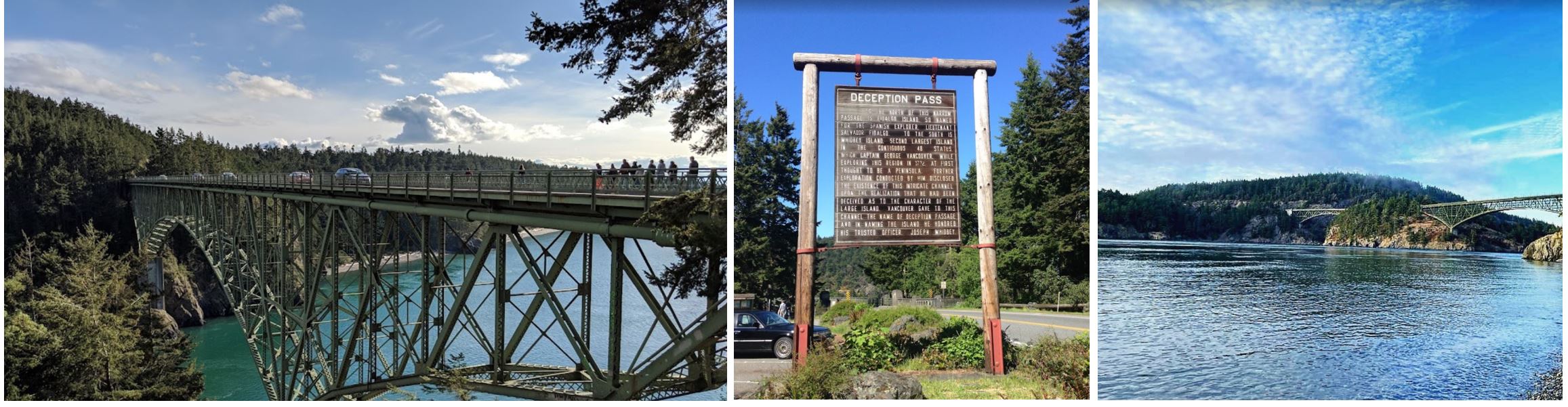
The next day we took a walk to a very picturesque little town called Coupeville, where Marky’s wife, Sheryl, grew up. On the way to Coupeville, we visited Deception Pass and Rosario Beach. Marky did an extraordinary job as a tour guide.
x
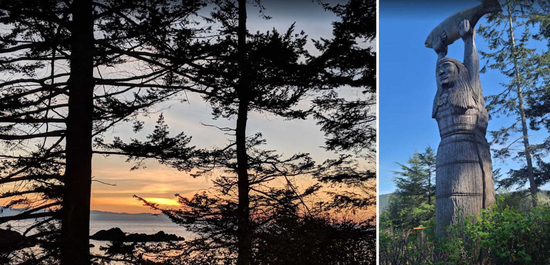
Rosario Beach falls within the Fidalgo Island parcel of Deception Pass State Park. Actually a set of two beaches, one on either side of a peninsula, Rosario Beach is a great sample of all that the park has to offer. Here you’ll find tide pools, wide beaches trimmed with driftwood, picnic areas set amongst old-growth trees and wildflower meadows, and a story pole carving. The carving is of Kwuh-kwal-uhl-wut, the Maiden of Deception Pass, who was a legend of the Samish, a Coast Salish Native American tribe and the first humans at Rosario beach. The other historic structures at Rosario Beach include a field classroom and rustic kitchen shelter build but the Civilian Conservation Corps in the 1930s.
x
x
Keep your eyes on the ocean, too, for a glimpse of porpoises, orcas, and the occasional gray whale.
Stretch your legs on the trail around Rosario head, or take the half-mile trail from the parking lot, which leads to nearby Bowman Bay.
A group of sailors led by Joseph Whidbey, part of the Vancouver Expedition, found and mapped Deception Pass on June 7, 1792. George Vancouver gave it the name “Deception” because it had misled him into thinking Whidbey Island was a peninsula. The “deception” was heightened due to Whidbey’s failure to find the strait at first. In May 1792, Vancouver was anchored near the southern end of Whidbey Island. He sent Joseph Whidbey to explore the waters east of Whidbey Island, now known as Saratoga Passage, using small boats. Whidbey reached the northern end of Saratoga Passage and explored eastward into Skagit Bay, which is shallow and difficult to navigate. He returned south to rejoin Vancouver without having found Deception Pass. It appeared that Skagit Bay was a dead-end and that Whidbey Island and Fidalgo Island were a long peninsula attached to the mainland. In June, the expedition sailed north along the west coast of Whidbey Island. Vancouver sent Joseph Whidbey to explore inlets leading to the east. The first inlet turned out to be a “very narrow and intricate channel, which…abounded with rocks above and beneath the surface of the water”. This channel led to Skagit Bay, thus separating Whidbey Island from the mainland. Vancouver apparently felt he and Joseph Whidbey had been deceived by the tricky strait. Vancouver wrote of Whidbey’s efforts: “This determined [the shore they had been exploring] to be an island, which, in consequence of Mr. Whidbey’s circumnavigation, I distinguished by the name of Whidbey’s Island: and this northern pass, leading into [Skagit Bay], Deception Passage”.
x
x
In the waters of Deception Pass, just east of the present-day Deception Pass Bridge, is a small island known as Ben Ure Island. The island became infamous for its activity of human smuggling of migrant Chinese people for local labor. Ben Ure and his partner Lawrence “Pirate” Kelly were quite profitable at their human smuggling business and played hide-and-seek with the United States Customs Department for years. Ure’s own operation at Deception Pass in the late 1880s consisted of Ure and his Native-American wife. Local tradition has it that his wife would camp on the nearby Strawberry Island (which was visible from the open sea) and signal him with a fire on the island’s summit to alert him to whether or not it was safe to attempt to bring the human cargo he illegally transported ashore. For transport, Ure would tie the people up in burlap bags so that if customs agents approached he could toss the bagged people overboard. The tidal currents carried the entrapped drowned migrants’ bodies to San Juan Island to the north and west of the pass; many ended up in Dead Man’s Bay.
Between 1910 and 1914, a prison rock quarry was operated on the Fidalgo Island side of the pass. Nearby barracks housed some 40 prisoners, members of an honors program out of Walla Walla State Penitentiary and the prison population was made up of several types of prisoners, including those convicted of murder. Guards stood watch at the quarry as prisoners cut the rock into gravel and loaded it onto barges at the base of the cliff atop the pass’s waters. The quarried rock was then barged to the Seattle waterfront. The camp was dismantled in 1924 and although abandoned as a quarry, the remains of the camp can still be found. The location is hazardous; over the years there have been several fatal accidents when visitors have ventured onto the steep cliffs.
Upon completion on July 31, 1935, the 976-foot (297 m) span Deception Pass Bridge connected Whidbey Island to the tiny Pass Island, and Pass Island to Fidalgo Island. Prior to the bridge, travelers used an inter-island ferry to commute between Fidalgo and Whidbey islands.
Puget Sound
Puget Sound is a sound of the Pacific Northwest, an inlet of the Pacific Ocean, and part of the Salish Sea. It is located along the northwestern coast of the U.S. state of Washington. It is a complex estuarine system of interconnected marine waterways and basins, with one major and two minor connections to the open Pacific Ocean via the Strait of Juan de Fuca—Admiralty Inlet being the major connection and Deception Pass and Swinomish Channel being the minor.
Water flow through Deception Pass is approximately equal to 2% of the total tidal exchange between Puget Sound and the Strait of Juan de Fuca. Puget Sound extends approximately 100 miles (160 km) from Deception Pass in the north to Olympia in the south. Its average depth is 450 feet (140 m) and its maximum depth, off Jefferson Point between Indianola and Kingston, is 930 feet (280 m). The depth of the main basin, between the southern tip of Whidbey Island and Tacoma, is approximately 600 feet (180 m).
In 2009, the term Salish Sea was established by the United States Board on Geographic Names as the collective waters of Puget Sound, the Strait of Juan de Fuca, and the Strait of Georgia. Sometimes the terms “Puget Sound” and “Puget Sound and adjacent waters” are used for not only Puget Sound proper but also for waters to the north, such as Bellingham Bay and the San Juan Islands region.
The term “Puget Sound” is used not just for the body of water but also the Puget Sound region centered on the sound. Major cities on the sound include Seattle, Tacoma, Olympia, and Everett. Puget Sound is also the second-largest estuary in the United States, after Chesapeake Bay in Maryland and Virginia.
x
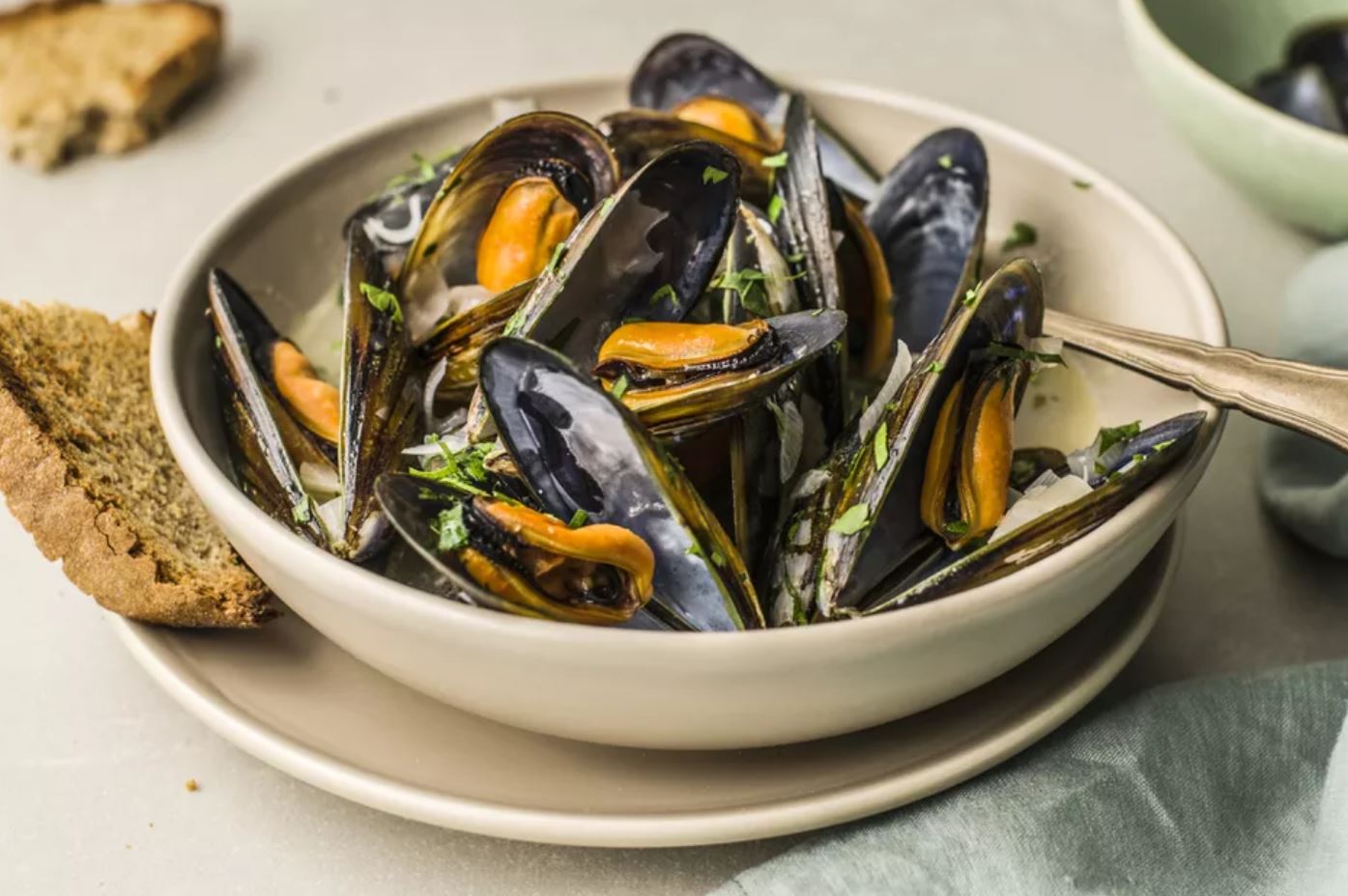
Coupeville is famous for its antique shops and for its mussels. After Spain, Coupeville is the world’s mussel capital. Of course, we all had mussel for lunch. It turned out to be a magical little town for us.
x
Coupeville is a town on Whidbey Island, in Island County, Washington, United States. It is the county seat of Island County. The population was 1,831 at the 2010 census.
Coupeville was laid out in the 1850s by Captain Thomas Coupe, and named for him. Coupeville was officially incorporated on April 20, 1910. Coupeville is a historic district within the federal Ebey’s Landing National Historical Reserve. The reserve was established by Congress in 1978 as the first and only National Historical Reserve in the nation. Its 22 square miles (57 km2) also encompass farmlands, Fort Ebey State Park, Fort Casey State Park, shorelines and beaches, parks, trails, and 91 buildings and structures on the National Register of Historic Places.
Mussel
Mussel is the common name used for members of several families of bivalve molluscs, from saltwater and freshwater habitats. These groups have in common a shell whose outline is elongated and asymmetrical compared with other edible clams, which are often more or less rounded or oval.
The word “mussel” is frequently used to mean the bivalves of the marine family Mytilidae, most of which live on exposed shores in the intertidal zone, attached by means of their strong byssal threads (“beard”) to a firm substrate. A few species (in the genus Bathymodiolus) have colonized hydrothermal vents associated with deep ocean ridges.
x
x
In most marine mussels the shell is longer than it is wide, being wedge-shaped or asymmetrical. The external colour of the shell is often dark blue, blackish, or brown, while the interior is silvery and somewhat nacreous.
The common name “mussel” is also used for many freshwater bivalves, including the freshwater pearl mussels. Freshwater mussel species inhabit lakes, ponds, rivers, creeks, canals, and they are classified in a different subclass of bivalves, despite some very superficial similarities in appearance.
Freshwater zebra mussels and their relatives in the family Dreissenidae are not related to previously mentioned groups, even though they resemble many Mytilus species in shape, and live attached to rocks and other hard surfaces in a similar manner, using a byssus. They are classified with the Heterodonta, the taxonomic group which includes most of the bivalves commonly referred to as “clams”.
Index
xxxxxxxxxx On our way to Centralia
xxxxxxxxxx Shopping at Safeway
xxxxxxxxxx Holy Water
xxxxxxxxxx Flip Wilson’s routine
xxxxxxxxxx At Beverly’s
x
xxxxxxxxxx On our way to Snohomish
xxxxxxxxxx Marky’s home in Snohomish
xxxxxxxxxx How the Loshes found Bob
xxxxxxxxxx Making Cuban Coffee
xxxxxxxxxx Sharpening Marky’s knife
x
x
xxxxxxxxxx Helen, Georgia
xxxxxxxxxx German restaurant in Florida
xxxxxxxxxx Colonia Tovar in Venezuela
xxxxxxxxxx Chonchita’s home
x
xxxxxxxxxx Rosario Beach
xxxxxxxxxx Deception Pass
xxxxxxxxxx On our way to Coupeville
xxxxxxxxxx Visiting Coupeville
x
x
xxxxxxxxxx Lunch at Shary
xxxxxxxxxx At Sharon’s
xxxxxxxxxx At the Bower’s
xxxxxxxxxx Old photos from Deer Park
xxxxxxxxxx Dennis Basketball Team
xxxxxxxxxx Onalaska General Store
x
xxxxxxxxxx I ain’t gone give nobody
xxxxxxxxxxxxxxxnone of my jolly roll
xxxxxxxxxx Nena Marinelli’s version
xxxxxxxxxx Emma Barrett’s version
xxxxxxxxxx New Orleans
xxxxxxxxxxxxxxxStompers’ version
x
2018
x
x
xxxxxxxxxx Monroe Road
xxxxxxxxxx Wild Rose Cemetery
xxxxxxxxxx Loshes’ Old Home
xxxxxxxxxx Sunflower field I
xxxxxxxxxx Sunflower field II
xxxxxxxxxx Wheat field
x
xxxxxxxxxx Entering Deer Park
xxxxxxxxxx Driving around Deer Park
xxxxxxxxxx Main Street Deer Park
xxxxxxxxxx Deer Park Hish School
xxxxxxxxxx 1st. Street Restaurant
xxxxxxxxxx Shopping at Yoke’s
x
xxx